

Thank you for being a regular reader of An Africanist Perspective. If you haven’t done so yet, please hit subscribe to receive timely updates on new posts along with over 36,000 other subscribers. New regular content is free. Book reviews and the archives are gated.
I: Maps are more than just projections on paper
A perennial theme on this blog is that ideas matter. Ideas define our mental models of how the world works, our perceptions of the feasible set of policy outcomes, and therefore play a significant role in either constraining or unleashing our sense of agency. It follows that representations that influence the ideas we take seriously also matter. It’s for this reason that I think that, all else equal, it was a great thing that African change-makers led by Africa No Filter and Speak Up Africa, as well as governments (led by Togo), helped ignite a conversation and then lobbied the UN to pass the resolution supporting the “Equal Earth” map.
As Howard French recently pointed out over at Foreign Policy, this is more than mere symbolism:
Acknowledging Africa’s geographic size goes hand in hand with the spreading understanding of the continent’s ballooning demographic weight in the world. Somewhat predictably, politicians in the West are behind the curve, still devoting remarkably little intellectual and policy capital to what will be one of the biggest drivers of global change for the remainder of this century. In fact, what little attention they do devote to Africa is of a largely reactionary nature.
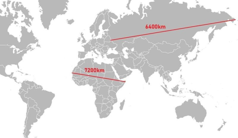
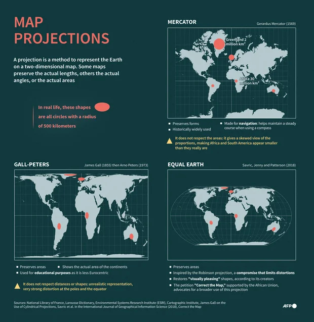
From an African perspective, the importance of the map change and the discourse around it is twofold. First, it’s an invitation for African countries to invest in different modes of understanding and mastering the physical world, as well as narratives of progress about the region.
To this end, it’s important to remember that the Mercator projection wasn’t created as an act of cartographic racism or imperialism. Instead, it was a mathematical invention that acquired global influence because it happened to be the one most favored by seafarers and dominant European maritime powers in the 16th century — leading to its total dominance two and a half centuries hence. Only later did it acquire political symbolism on account of European (neo)colonialism. Therefore, and sticking to the theme of crafting useful models of the world as Mercator did, the push to replace his map ought to be accompanied by a generalized Continental drive to study, understand, and master the physical world — from cadastral surveys, to pedological revolutions, to mineral prospecting, to geotechnical engineering.
The point here is that critics of the Mercator projection should not fall into the temptation of merely expressive rhetorical debates characterized by weak strawman arguments about its origins (like was the case with the Peters Projection debate in the 1970s). While it’s fair to criticize ignorant (mis)uses of the Mercator map, the principled response would be to provide a positive veto in the form of a technically sound new map (as has happened) and a renewed push within the Continent to understand and master the physical world (as should happen). Recall that millions of copies of Arno Peters’ map were circulated around the world in the 1970s and 1980s to little effect. This time must be different. Again, it helps that, to start with, the Patterson-Savric-Jenny “Equal Earth” map is technically sound and largely accepted among cartographers (unlike Peters’ map).
Second, the map change is a useful dramatization of the temporal nature of the global distribution of economic and political power. Change is the only constant in history, and organized people can find and exercise agency even in the tightest of corners. In other words, there’s absolutely no reason why the next 500 years of African history should mirror the humiliation and dispossession that characterized most of the last 500 years. People alive today can consciously shape the future — by litigating the past as an exercise in foundational building (never underrate the power of historical consciousness), and also giving progress a chance (by imagining and working towards new futures). Put differently, wallowing in cynicism and/or capitulating to historical determinism are cowardly choices.
II: Fixing the world will only partially fix African countries
That said, I’d like to emphasize a point I made in an interview with FT’s David Pilling, and (admittedly) project other thoughts and ideas onto the discourse on maps. To reiterate, the map change as an ideational shift regarding our knowledge and understanding of the physical world and how it works will only matter to the extent that it changes mental models on the Continent and spurs people to action.
The next question to ask then is why we needed a map change at the UN to motivate specific changes across the continent. Given that these debates have been with us since at least the 1970s, why do African schoolchildren still get taught using Mercator projection maps (if that)? Why didn’t African cartographers move ahead with producing and using maps that make sense for the region even if other parts of the world stuck with the old map? Where’s the regulatory push to force digital platforms to use the correct maps for the region?
The answers to these questions are multilayered. The first layer relates to African leaders and policymakers. The failure to change maps reflects the fact that: (1) objectively speaking, leaders and policymakers had bigger fish to fry given the budget and cognitive constraints they faced; (2) an abiding lack of historical awareness; (3) disregard of education as a developmentalist tool and conduit for disseminating useful knowledge (in the Mokyr sense) — see the decline of STEM; and (4) a general deference to externally produced knowledge as the only source of “universal knowledge.”
Notice that this gap extends to colonial place names and symbols. Some were, embarrassingly so, never changed; while for others the changes are yet to be reflected on digital maps.
The second layer is related to the question of how non-state African actors (especially progressive change agents) leverage the external world for domestic ends (along the lines explored in Daniel Branch’s book on Tom Mboya). In a sense, the move to fix the world map via the UN invites us to consider two theories of change (both of which have their merits and demerits). At face value, the UN initiative is a form of worldmaking in that it’s an effort at changing the prospects of African societies and countries by changing global perceptions of the region. A different and somewhat contrasting approach would be to push for change through localized attention to problems and potential solutions in specific African countries. In the case of maps, one would focus on changing a specific country’s textbooks, public maps, and regulation to reflect the correct projection, then leveraging the demonstration effect of the success to effect change elsewhere.
The reasonable approach, of course, is to balance both with varying degrees of emphasis across time, space, and specific issue areas.
Surprisingly, though, lots of people out there do and say things that betray a maximalist belief in one approach as the only game in town. In particular, there tends to be an international bias among progressive change agents — mostly because governments often aren’t willing to change (which makes it more likely to move them via the signaling power of external validation); change agents are typically policy outsiders so gravitate to international fora where they can have expressive impact; a lot of change agents rely on foreign support, and so have to signal their effectiveness in ways that are readily legible to their external funders; and because even progressive change agents aren’t immune to policy extraversion (independent of the incentives created by foreign financial dependence).
This is not a critique per se of internationally focused advocacy. As a general matter, Africa’s future will remain closely tied to how it integrates into the world (think credit markets, trade and investment rules, labor mobility, carbon regulation, and the like). It follows that changing the world is a core part of ensuring a better future for Africa and Africans.
At the same time, changing the world is not enough. Those efforts must be anchored in clear domestic agendas for change. This calls for a calibration that balances externally focused push for reforms, with dogged attention to progressive change. And as noted above, the specific calibration of the balance ought to depend on issue area, time period, and political economy context.
III: Conclusion
In the final analysis, I think it’s fine that we are projecting so much onto the UN vote on map projections and the advocacy behind it. I also think, and here I agree with French, that similar efforts by Africans to remake the world in their image will only accelerate (and therefore the world better get used to it). My only caution is that these efforts shouldn’t just be extraverted and expressive. Instead, they must also be accompanied by contextualized domestic production of useful knowledge and push for policy change in ways that will have material impact on Africans’ lives. At the end of the day, all that will matter is whether or not the causes to we choose to allocate cognitive and material resources result in improvements in human welfare in Africa.
The Mercator map was useful for navigation, particularly at sea. It's a conformal mapping so that an angle between two great circles on a globe would be the same as on a flat map. Great circles are the shortest distance between two points on a sphere, so one would like to sail a great circle route and likely have to cross meridians of longitude which are great circles as well. It wasn't a great technology, but it worked well enough.
https://substack.com/profile/275088212-flow/note/c-337861085?r=4js3f8&utm_medium=ios&utm_source=notes-share-action